Pico de Orizaba was an objective long before we arrive in Tlachichuca, the common staging town for climbing the mountain. It’s a dormant stratovolcano that rises 5600 meters above sea level. Pico de Orizaba or Citlaltepetl, as it’s also known, holds the honour of being Mexico’s tallest peak and the third tallest peak in North America after Mt. McKinley and Mt. Logan, both of which had been only a relative stone’s throw away on the first leg of our journey in the Yukon Territories and Alaska. While McKinley and Logan were beyond our resources and probably our abilities Pico de Orizaba was within reach. The ascent is non-technical so the greatest challenge is elevation. For this reason Citlaltepetl is a great first high altitude peak. Despite all this we almost drove right by without even checking it out. The weather forecast was calling for almost 5 meters of snow in the alpine over the 5 days we were planning to be there. It seemed like we were out of luck, but in the mountains weather forecasts are rarely reliable so we decided to stop in at Tlachichuca and see first hand how things were looking.
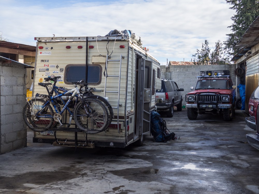
In typical character we arrived in Tlachichuca on a Thursday without much of a plan. Based on some research on summit post we knew that there was a climbers hostel in town called Canchola’s House. After a bit of searching we found it, and the owner Joaquin waved us into their charming little courtyard. We couldn’t have been happier to end up at Canchola’s House. Joaquin and his daughter Maribel’s kindness and hospitality are unparalleled. They made us feel truly at home, which is a hard feeling to find on the road. We learned from Joaquin that it had not actually been snowing on the mountain, and there was a window of good weather on Saturday and Sunday morning. We met a group of Mexicans guys from San Louis who were heading up to the Piedra Grande hut at the base of the mountain that evening to acclimatize on Friday and go for the summit on Saturday. So it looked like we had a shot after all. It was too late to get ourselves organized to go that evening but we arranged to go the next day. From Tlachichuca it’s a 2 hour drive to the hut. You need a serious 4×4 to get up the road so we left the camper at Canchola’s and got a ride up in one of his old jeeps.
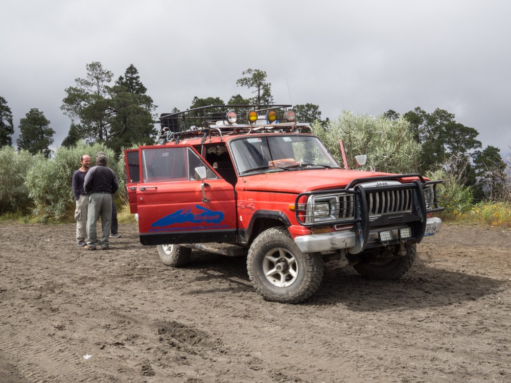
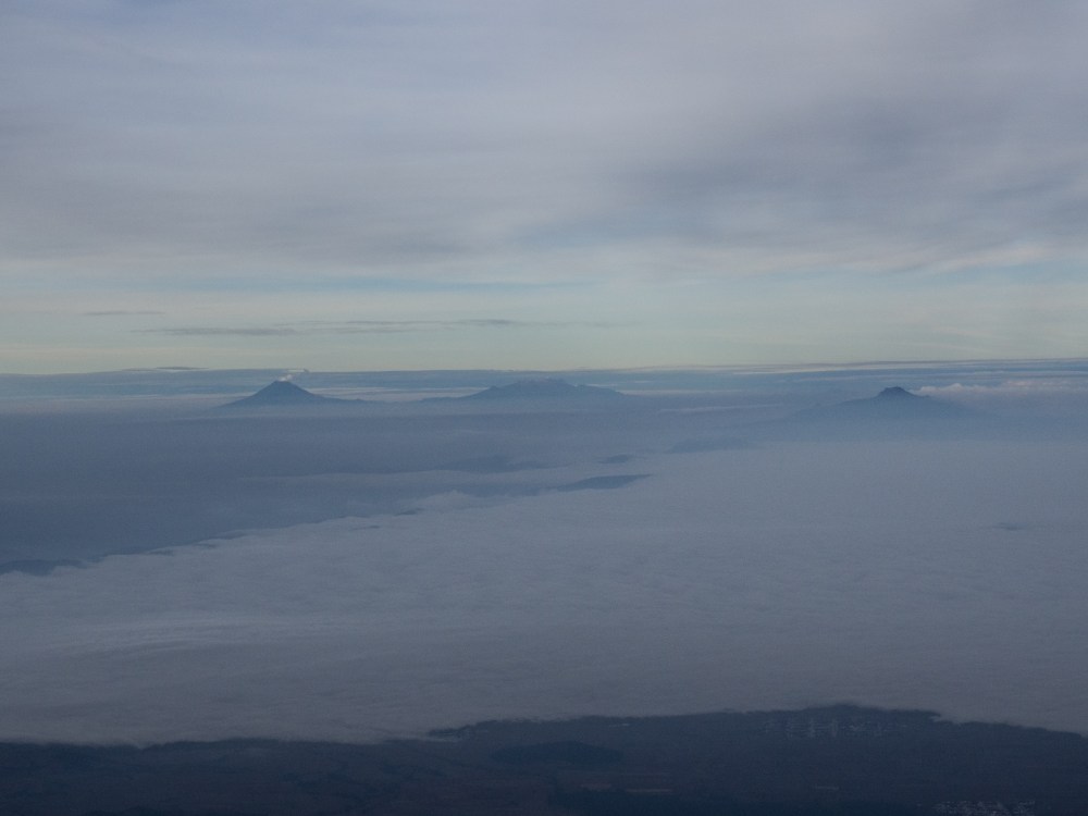
The ride up the mountain was bumpy but beautiful, as we wound our way through coniferous trees shrouded in mist. We were lucky to share a ride with Alvarro of 3 summits guides. He helped us out with great information about the climb, especially welcome as I had never climbed anything this big before. Joaquin delivered us safe and sound to Piedra Grande (4267m) the free climbers hut at the base of Citlaltepetl. Stepping out of the jeep we felt light headed, and unloading the gear was harder than it should have been, effects of the altitude. We had breathtaking views of the clouds and hills below. We set up in the hut, made some lunch, and headed out the door for an acclimatization hike. It was raining and socked in as we left, but shortly the sky opened up and treated us to a few rays of sunshine. We ascended to about 4600m in the upper valley before turning back to the hut and felt pretty good.


Back at the hut we were faced with a decision. The best weather window was tomorrow (Saturday) with weather predicted to blow in Sunday afternoon. Hurricane Patricia was predicted hit Puerto Vallarta on Sunday as well. Although Citlatepetl is a great distance from the west coast the hurricane was predicted to affect weather across the country. Messages were coming in over our Inreach device warning us to beware of the impending storm. Joaquin and Alvaro however didn’t think the hurricane was going to be a threat. The consensus locally was that the hurricane would strike North of us and move north. Nonetheless the incentive was strong to go for the summit the next day when the weather was most likely to be good. The problem was that we had gained altitude quickly, and really needed another day to acclimatize properly. We decided to make a game time decision based on how we felt in the morning, and set the alarm for midnight to hopefully make an alpine start.

Morning came and we dragged ourselves out of bed. I was in business mode getting breakfast prepared and pulling the last of the gear together. With the exception of a mild headache, a constant fixture since we got to the hut, I was feeling good to go. It took a few minutes for me to notice that Jessa wasn’t eating. She told me that she was feeling nauseous and couldn’t keep her breakfast down, a sign of altitude sickness. We knew we would be pushing it to summit that day, and given the early signs of altitude sickness, decided to go back to bed and try for the next. Jessa asked if I wanted to try to go with another group. I badly wanted to go for the summit, but I decided that it would be a lot more special and rewarding if we could make it together.
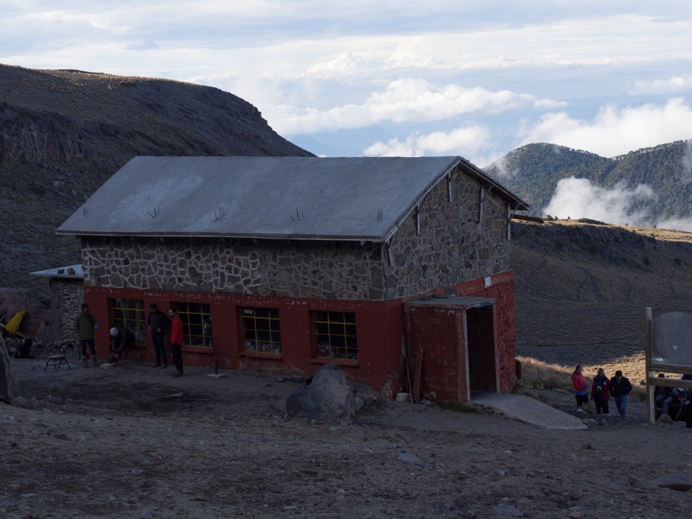
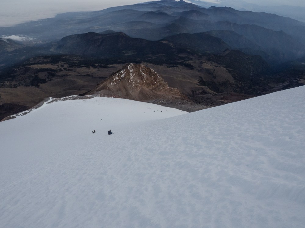
The next day brought bluebird skies and many parties made the summit. We went for our second acclimatization hike, this time going almost to the base of the labyrinth (4800m). It was a great hike in itself. The Labyrinth is a steep rocky section, exposed by the receding glacier. It was good to get a look at it. As the name suggests, route finding in this section can be difficult, especially in the dark. After a long lunch we picked our way back down to the hut. We were quite tired and I hoped we hadn’t expended too much energy in trade for better acclimatization and scouting the route. While we were on the mountain the hut had filled up with climbers. Hoping for a better sleep we set up the tent nearby and crashed there as early as we could to be prepared for the next day’s planned summit push.


Probably do the excitement of summiting and the effects of the altitude I couldn’t sleep that night. I did at least get some rest though. The alarm went off once again, this time at 11pm to allow us as much time as possible to summit. I could see lightning striking in the valley below us, we would need to watch the weather closely. We started to get ready, but it was quickly evident that once again Jessa wasn’t feeling well. Hoping that she might be able to walk it off we started up the mountain by moonlight. Unfortunately things didn’t get better. We quickly decided that given the threatening weather and Jessa’s worsening altitude sickness it would be best for her to turn back. It was really unfortunate as I had hoped we could do it together. We quickly redistributed some gear and food and I pushed ahead to try to catch a group of Mexican guys ahead that I had met the day before while Jessa made her way back to the hut.
Traveling alone I moved quickly and I felt strong, but I still wasn’t feeling too optimistic about making the summit given the threatening weather. Evidently the group of Mexicans was moving quickly too because I didn’t catch them until we were well into the labyrinth. I made frequent shoulder checks to keep an eye on the weather. The lightning down below in the valley was building into a massive storm cloud, now rising well above me. Evidently the result of hurricane Patricia. The storm was building, but it was keeping its distance so I elected to continue. I could see headlamps ahead of me in the dark. Just as I reached the group ahead one of their members slipped on an icy section in the steep rocky labyrinth. He couldn’t arrest the fall and came crashing down towards me, sliding down a frozen stream. Luckily he came to a stop after about 7 meters, bruised but nothing broken. After checking that he was ok I put on my crampons to tackle the icy section. He went ahead of me to try again without. We all made it up safely, and I linked up with their group briefly as we worked our way up to the glacier.
At the glacier we took a break and surveyed the weather. The storm to the North was now clearly in retreat, well off in the distance. We felt comfortable to go for the summit. We geared up with axes and crampons and started chipping away at the deceptively long glacier. The other group didn’t have space for me on their rope, so I went up solo. The snow was excellent for travel with crampons, and I knew from speaking with local guides that there was little to no risk of falling into a crevasse.
Traveling alone again I made quick progress navigating by moonlight. Although it was retreating, the storm was still raging in the distance. Lightning strikes periodically illuminated the glacier, punctuating the soft moonlight. The air was very still. It was a surreal experience to be so exposed on the side of the volcano in the proximity of nature’s fury.
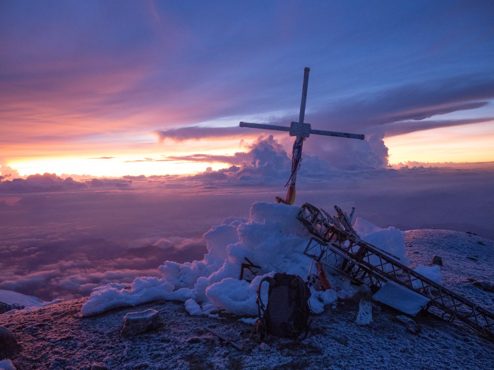
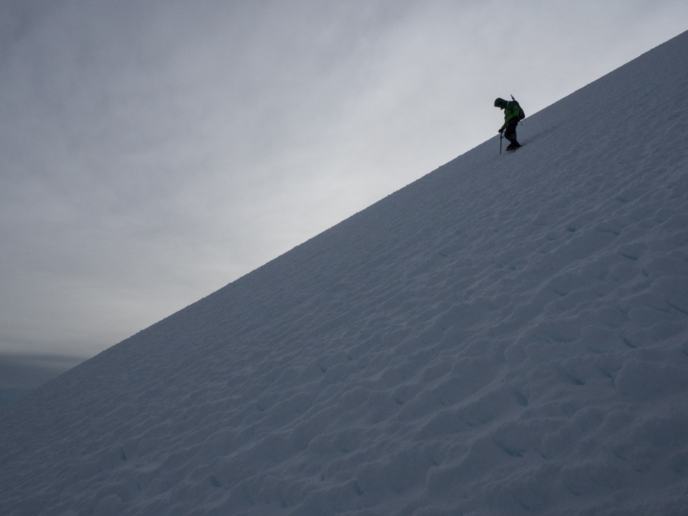
As I continued to work my way up the glacier the moon gradually moved behind the clouds and it became dark. I switched on my headlight and my world was reduced to the beam of light cast at my feet. The glacier steepened gradually, maxing out at about 45 degrees. In the dark the slope felt especially steep and I was increasingly feeling the effects of the altitude. I focused hard on my foot placements and keeping my balance, taking five steps at a time and then a short break. At first I occasionally shone my light up the slope, but it always kept rising on and on out of site, so eventually I just focused on my feet. Only after an epic slog, as faint purples and reds in the sky signalled the impending sunrise, did the summit come into view. I was lucky with my timing. As I crested the summit ridge I was treated to views of the sheer walls making up the sides of the crater, the bottom of which was out of site far below. The sunrise bathed everything in spectacular purple and yellow light. To the west the active volcano Popo could be seen smoking alongside the distinctive volcano Izta, shaped like a sleeping woman. To the south I looked down on the Large Millimeter Telescope on the summit of Sierra Negra. Gradually the two other groups arrived at the summit and gratuitous congratulations and high fives were shared by all. We bonded over standing on the peak together.


Eventually we had to head down the mountain, I went down with my new amigos from Guadalajara and Mexico City. I could tell right away that I had been on the top for too long though, as I had developed a rough cough and the head ache was worsening. Descending the glacier is about as strenuous as ascending, and it’s wise to step carefully as most accidents happen on the way down. We worked our way down gradually, eventually reaching the base of the glacier and then made the long walk back down to the hut. It took longer than going up. My altitude sickness continued to worsen as we went down, but some Gravol and Advil got me through it. Back at the hut Jessa was waiting with a warm cup of soup. I couldn’t have imagined a better reward, and soon the sickness passed. I had time for a 15 minute nap before Jessa found us a ride down. We threw everything into the jeep and bounced and jostled our way back down to Tlachichuca. Climbing Pico de Orizaba was challenging and rewarding. I was proud of making it to the summit, but we were both ready get down to lower elevation and head to the coast for some more surfing.


T

you should be a writer – many many thanks for sharing- almost like I am travelling myself- love it
LikeLike